There’s an app for fishers that acts much like a weather forecast – it pulls in data from a range of sources and forecasts where fishing operations could take place to fish sustainably and avoid endangered species.
Mandated bycatch reduction measures in the Californian swordfish fishery provided the impetus to design the EcoCast app.[1] Fishers used an indiscriminate drift gillnet method in the Californian swordfish fishery, which led to high rates of bycatch of critically endangered leatherback turtles[2] and beaked whales.[3] In 2001, there were two management tools applied to address this – establishment of a static conservation area and mandated gear modifications.
These management tools led to a significant reduction in swordfish catch, well below levels that could maintain sustainable harvest, and challenged the economic viability of the fishery.
The issue in California highlighted an ongoing tension in fisheries management – it’s difficult to balance sustainable target catch with species protection using static approaches. The dynamic nature of fisheries means that opportunities to fish sustainably and economically may be lost with enduring area closures. Researchers sought to address this issue by designing a tool that supports dynamic ocean management.[1]
Launched in 2017, EcoCast takes an array of live ocean conditions and known species distribution patterns for target and bycatch-sensitive species into account to generate a fluid map to guide fishing efforts.
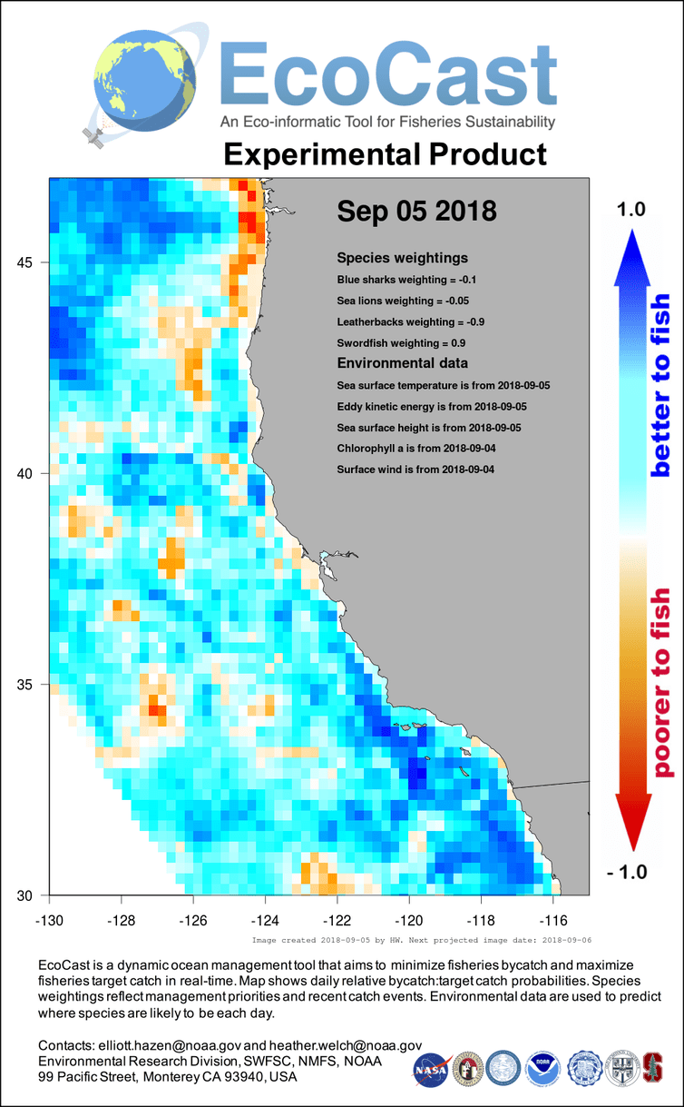
Satellite data for an array of ocean conditions such as sea surface height, temperature and chlorophyll concentration is collected daily. Mathematical models are then used to predict where species of interest would be distributed based on these conditions. The predictions are then overlaid for different species to create a map with predictions designed to help fishers figure out where they are most likely to find the species they want to catch and least likely to find the species they want to avoid. The map is updated daily and scaled for the day’s data (see figure on right). Importantly, users can weight the importance of different species. For example, if turtles are breeding users can ask the app to prioritise avoiding turtles in issuing guidance on where to fish. Essentially, the app guides fishers towards areas of high concentration of their target species and away from protected ones.

The EcoCast map from September 5, 2018, showing waters that are better and poorer to fish. Image credit: NOAA.
The app is now used to allow fishers exemptions to fish in certain protected areas in California. This demonstrates the utility and power of being able to integrate multiple datasets in near real time to inform management decisions (the need for which is discussed in the section ‘Changing fisheries demand nimble and responsive decision making’). The modelling software integrates complex data but presents through an easy-to-understand interface that is openly accessible to fishers. This means that the benefit to fishers is obvious and easily realised. Fine tuning of the model and app is ongoing and integrating information from different spatial and temporal timescales, derived with different tools, continues to be challenging.
The app is now used to allow fishers exemptions to fish in certain protected areas in California.
Novel tools like EcoCast could be applied in Aotearoa New Zealand fisheries so that sustainable fishing operations can continue alongside protection of endangered and non-target species. It’s easy to imagine the use in our local context, where species like Māui dolphins would be given extra high weight to avoid.
Having more data and information about our oceans, marine species and fisheries practices will open up new opportunities to implement moving management options. Through these approaches the most sustainable and economic fishing methods can be utilised while protecting vulnerable species.
